


BaseMap: 3D Hunting Maps & GPS
BaseMap Inc
When I first opened BaseMap, I understood the appeal immediately: it turns a phone into a planning and navigation tool for outdoor trips, with map layers, GPS positioning, weather information, land-ownership details, and location sharing gathered in one place. That combination is more useful than a basic road map when I am thinking about a hike, scouting an area, checking access, or trying to stay oriented away from familiar streets.
At the same time, this is not an app I would recommend simply because it has an impressive-looking map. The real question is whether it becomes part of your routine after the first few outings. In my experience, its lasting value depends on how often you spend time outdoors, how much planning you do before leaving, and whether you are willing to prepare maps and settings instead of treating the phone as a magic replacement for every other navigation tool.
BaseMap is a free sports app from BaseMap Inc, rated for Everyone. It has passed half a million installs, which gives it a meaningful user base without making it feel like a general-purpose social platform. The current version is 7.0.1, and it runs on Android 8.0 or later. Optional purchases range from $3.99 to $99.99 per item, so the initial download is easy to try, but serious users should think about which parts of the experience they actually need before spending money.
Why the first week feels so useful
The strongest first impression comes from the way the app puts several outdoor decisions beside the map. I can look at terrain in a more visual way, check where public and private land meet, use GPS to understand my position, and consider weather or wind before committing to a route. None of those tools is revolutionary by itself, but having them together reduces the constant switching between a map app, a weather app, and notes about access.
The three-dimensional map view is especially good for the planning stage. A flat map can show lines and labels, but a 3D perspective helps me form a mental picture of slopes, ridges, valleys, and the general shape of an area. I would not use that view as the only basis for a safety decision, yet it is a practical way to decide where a route might become tiring or where a viewpoint could be easier to reach than it first appears.
Related News

Why WhatsApp Messenger Still Makes Everyday Communication Feel Easy

Jurassic World: The Game Is the Better Dino Tycoon for Strategic Players

Threads in Real Life: Who Should Join, Lurk, or Leave
How SHEIN Turned Shopping Into an Endless Content Feed
How to Make Fortnite Feel Smarter on Mobile

Should You Switch to Microsoft Outlook on Mobile?
That early planning benefit is where many people will feel the app is worth keeping. Before a weekend outing, I can inspect an unfamiliar area from home, mark the places that deserve a closer look, and use the land information to avoid making assumptions about access. The value is not just seeing more map detail; it is reducing the number of small unknowns that can spoil a trip.
Location sharing adds another useful layer. If I am meeting someone outdoors, sharing a position can be more helpful than describing a trail junction or sending a vague text such as “I am near the ridge.” It also supports a simple check-in habit: I can let another person know where I am expected to be working or exploring. I still would not treat sharing as a complete emergency plan, because it depends on sensible preparation and communication outside the app as well.
Weather and wind information are most useful when they change a decision rather than merely confirm the forecast I already expected. Wind can matter for exposed terrain, comfort, and the way conditions feel at a higher point. I found these details more valuable when checking them alongside the map, because the same forecast can mean something different on an open ridge than in a sheltered area.
Gallery
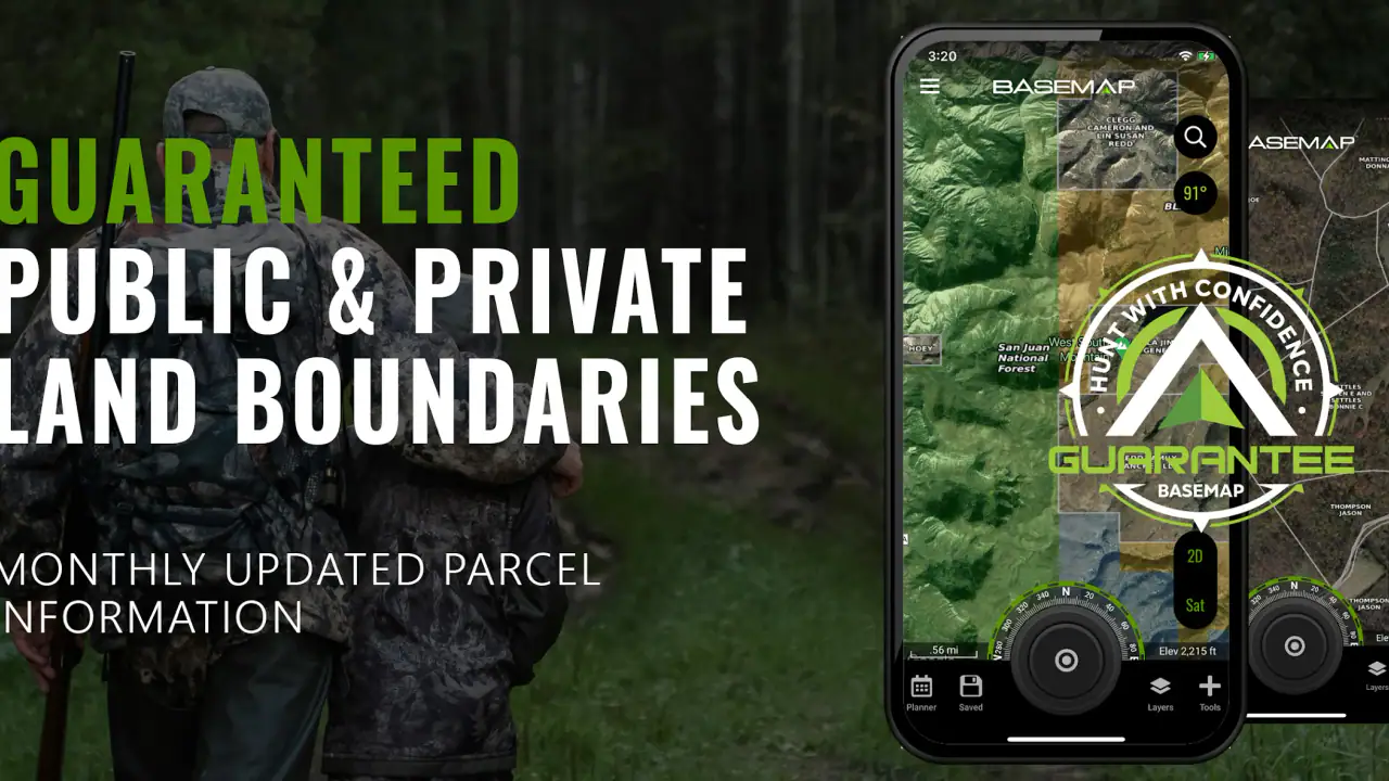
The practical first-week workflow is straightforward. I start by finding the area, switch between the map views, inspect land boundaries, check the weather and wind, and then use GPS once I am outside. That sequence makes the app feel less like a collection of features and more like a preparation tool. The important tip is to plan with the map before arriving, rather than waiting until the phone is already being used in poor reception or uncomfortable conditions.
A realistic weekend use case
Imagine I am planning a day outside with a friend in an area neither of us knows well. The night before, I use the 3D view to understand the terrain, check public and private land boundaries, and look at the expected wind. I share my location or meeting point so my friend has the same reference. Once we arrive, GPS helps us relate our position to the planned area instead of relying only on trail signs.
That workflow does not guarantee a perfect day, but it removes several avoidable mistakes. We are less likely to choose a route without considering the terrain, less likely to wander across land we should not enter, and less likely to ignore conditions that may make an exposed section unpleasant. This is a concrete advantage over using a standard map alone.
What remains valuable after the novelty fades
After the first few outings, the app has to earn its place through repetition. For frequent hikers, hunters, anglers, campers, and other outdoor users, the recurring value comes from making the same preparation steps quicker. I can return to a familiar region, review the land context, check current conditions, and use the same GPS reference without rebuilding my process from separate tools.
The public and private land information is one of the features most likely to justify continued use for people who regularly explore unfamiliar areas. It is not simply a decorative layer. It changes how I evaluate a possible route, where I might stop, and whether a promising-looking line on the map is realistic from an access point of view. The trade-off is that map information should be treated as a planning aid, not as permission by itself. I would still verify local rules and any restrictions that apply to the activity.
Offline 3D mapping is another reason the app can remain useful beyond the trial period. Outdoor connectivity is unreliable, and depending entirely on a live connection is a poor habit. Preparing the relevant map area before leaving is therefore one of the most important routines I would recommend. The hidden cost is preparation time: offline tools are valuable only when I remember to set them up before the trip, not when I discover their importance after losing service.
GPS is most helpful when I use it to answer a focused question. Am I still near the planned route? Which side of a boundary am I on? How far have I moved from the meeting point? Those questions are easier to handle than constantly staring at the screen. A useful habit is to check position at natural pauses, then put the phone away and continue paying attention to the surroundings.
Location sharing also becomes more valuable with repeated use because it can support a consistent group routine. A family member, friend, or trip partner can have a clearer idea of where I am working or moving. Still, I would avoid turning it into a substitute for telling someone the destination, expected return, and backup plan. The app can support communication, but it cannot make an unplanned trip safe by itself.
The rating of 4.0 from around 4.6 thousand ratings suggests a generally positive but not universally perfect experience. That matches my view. BaseMap is strongest when I use several connected tools in one outdoor workflow. Someone who only wants a simple direction arrow may find it more involved than necessary, while someone who repeatedly plans trips around terrain and land access is more likely to appreciate the depth.
How it compares with ordinary alternatives
A conventional navigation app is usually better for city driving, addresses, businesses, traffic, and familiar road journeys. I would not replace that kind of app with BaseMap for everyday commuting. BaseMap makes more sense when the important questions involve terrain, land status, outdoor positioning, weather, and preparation away from ordinary streets.
Using several specialist apps can offer more focused information in each area, and some users may prefer that separation. The downside is switching between screens, reconciling different map views, and remembering which app contains which detail. BaseMap’s advantage is concentration: the outdoor planning context stays together. Its disadvantage is that a combined tool may not satisfy someone who wants the deepest possible treatment of one narrow function.
Paper maps still have a place, especially as a backup. They do not run out of battery, and they encourage a broad view of the area. BaseMap is more flexible for checking position, viewing different perspectives, and sharing a location. My preferred approach is not to choose one blindly: I use the app for active planning and GPS reference, while keeping basic offline awareness and a backup plan for trips where failure would matter.
The maintenance burden of keeping it dependable
The app is not difficult to maintain, but it rewards users who develop a checklist. Before leaving, I would confirm that the intended area is available for offline use, inspect the route at a useful zoom level, review weather and wind, and make sure the phone has enough battery for navigation. Those steps are not glamorous, yet they determine whether the app is genuinely helpful outdoors.
Map preparation is the most important recurring task. An offline map does not help if I saved the wrong place, selected too small an area, or forgot to prepare it at all. I would rather spend a few minutes checking the planned region at home than assume I can solve everything after arriving. This is one of the clearest differences between casually installing the app and building a reliable habit around it.
Battery management matters too. GPS use, a bright screen, and long periods of map viewing can make a phone less dependable over a full day. I would avoid leaving the display active continuously and would carry an external battery for longer trips. That limitation belongs to phone-based navigation generally, but it is easy to overlook when the map feels convenient during the first few minutes.
Permission and sharing choices deserve attention as part of the setup. Location sharing is useful only when I understand who will receive the information and when it should be used. I would review those choices before a trip rather than changing them hurriedly in the field. This is a small maintenance habit, but it prevents the convenience of sharing from becoming careless oversharing.
The optional purchase structure also affects long-term commitment. Since the app is free to start and offers in-app items from $3.99 to $99.99, I would begin with the functions that solve my actual problem instead of assuming every upgrade is necessary. A casual user may be satisfied without making a major investment, while a person who relies on advanced mapping for regular outdoor work may consider paid access more reasonable.
Where regular use can become tiring
The biggest source of fatigue is the amount of attention a detailed map can demand. More layers and perspectives can improve decisions, but they can also tempt me to keep inspecting the screen instead of observing terrain, signage, weather, and other people. The best experience comes from using the app in short, purposeful checks rather than treating it as a constantly open dashboard.
Another friction point is the gap between planning confidence and real-world conditions. A 3D map can help me understand the shape of an area, but it does not replace judgment about mud, fallen trees, changing weather, visibility, or personal fitness. Land information can guide access planning, but it does not remove the need to respect posted rules. GPS can show position, but it does not tell me whether the safest choice is to continue.
The app may also feel excessive for people whose outdoor activity stays on well-marked routes. If I already know the trail, have reliable signs, and only need a basic forecast, the extra map context may not justify another app or a paid feature. In that situation, a simpler navigation tool could be quicker and easier to maintain.
Users who dislike preparing anything before a trip may also become frustrated. Offline mapping and careful route review are not completely automatic habits; they require a little forethought. If I repeatedly open the app only after reaching a remote location, I am using its strengths at the least convenient moment. That is not a flaw unique to BaseMap, but it is an important reason some people will abandon it after the initial excitement.
There is also a learning curve in deciding which information deserves attention. A new user may spend too much time comparing views or following every available detail. My advice is to choose one main purpose per outing: access planning, route orientation, weather awareness, or location sharing. Once that purpose is clear, the interface feels less busy and the app becomes easier to use consistently.
Who should keep it installed
I would recommend BaseMap to people who spend regular time outdoors and want one planning space for terrain, land context, GPS, weather, wind, and sharing. It is particularly appealing when trips involve unfamiliar areas, changing conditions, or a need to think carefully about where movement is appropriate. The combination is more valuable than any single feature viewed in isolation.
It is also a good fit for someone who likes to prepare. If I enjoy studying an area before visiting, saving offline map information, and building a repeatable checklist, the app can become a dependable part of my routine. Its strongest users are not necessarily the people who explore the most dramatically; they are the people who use the same preparation habits often enough for the app to save time.
I would suggest skipping it if the main need is turn-by-turn driving, city directions, business searches, or a very simple walking map. I would also hesitate to recommend it as a sole safety resource for demanding trips. A phone can fail, conditions can change, and map information cannot replace local knowledge, sensible equipment, or a clear plan shared with another person.
The age rating of Everyone makes it approachable for a broad audience, but ease of access should not be confused with automatic outdoor readiness. A young or inexperienced user still needs guidance about navigation, weather, boundaries, and battery planning. The app can support good habits; it cannot create them without the user’s attention.
My long-term verdict
BaseMap earns lasting space on my phone when I use it as a preparation and field-reference tool rather than as a novelty 3D map. The first week is engaging because the views are informative and the map combines several outdoor concerns. The following months are where it proves itself: offline preparation, land-awareness checks, GPS reference, weather review, and practical location sharing can become a repeatable routine.
Its limitations are equally clear. It asks for setup, can encourage too much screen time, and may be more complicated than necessary for casual outings. Optional purchases mean I would evaluate my real usage before committing money, especially if I only go outdoors occasionally. For serious trips, I would pair it with backup planning instead of trusting any single phone app completely.
My final recommendation is therefore conditional but positive. If your outdoor decisions regularly depend on terrain, access, conditions, and knowing where you are, BaseMap is worth trying and has enough practical depth to remain useful after the first impression. If you only want simple directions or rarely leave familiar routes, the extra detail may become maintenance rather than help. For the right user, the lasting value is not the novelty of the 3D view, but the habit of making better-informed outdoor plans.
FAQs for BaseMap: 3D Hunting Maps & GPS
What is BaseMap: 3D Hunting Maps & GPS used for?
BaseMap is a navigation and outdoor mapping app designed primarily for hunters, hikers, and other backcountry users. It provides detailed topographic maps, property boundaries, public and private land information, satellite imagery, and GPS tracking tools. Hunters can use it to plan trips, mark locations, study terrain, save waypoints, and navigate more confidently in unfamiliar areas.
Does BaseMap work without an internet connection?
Yes, BaseMap supports offline map use, which is especially important in remote hunting areas with limited or no cellular service. Users can download map sections before leaving home and access important terrain and property information later. It is still recommended to prepare carefully, download all required regions, keep the phone charged, and avoid relying on the app as the only navigation or safety tool.
Is BaseMap free, or does it require a subscription?
BaseMap offers free features, but some of its most useful tools and data layers may require a paid subscription. Premium access can include enhanced property information, advanced hunting layers, offline functionality, weather or tracking tools, and additional planning resources, depending on the current plan. Before subscribing, review the available features, billing terms, and renewal conditions in the app store.
How accurate are BaseMap’s property boundaries and hunting maps?
BaseMap combines several types of mapping and land-management information to help users understand terrain, ownership, access, and hunting conditions. However, map accuracy can vary by region, data source, update schedule, and local changes. Property lines and access information should be treated as helpful reference material rather than legal proof. Always verify regulations, boundaries, permissions, and closures with official local sources.
Can BaseMap replace a dedicated GPS device or paper map?
BaseMap can be a powerful navigation companion, but it should not be considered a complete replacement for a dedicated GPS unit, compass, or paper map in every situation. Smartphones can lose battery power, suffer from weather damage, or experience technical problems. For serious backcountry trips, carry backup navigation equipment, spare power, emergency supplies, and a clear understanding of the area before setting out.
Pros
- Detailed 3D terrain maps make it easier to understand elevation and land features.
- Offline map downloads help maintain navigation in areas with weak or no signal.
- Hunting-specific layers show public land
- boundaries
- roads
- and useful access points.
- GPS tracking lets you record routes
- waypoints
- and important hunting locations.
- Frequent map updates can provide more reliable property and terrain information.
Cons
- Many advanced map layers and tools require a paid subscription.
- Offline downloads can use considerable storage on your phone.
- Battery usage may increase during extended GPS tracking sessions.
- Coverage and property details can vary by region and local data availability.
- The wide range of map layers may feel overwhelming for first-time users.


